Major Winter Storm Unleashes Ice and Snow Across Great Lakes and Northeast, NYC Braces for Heaviest Snowfall in Years
A significant winter storm is set to bring a potent mix of ice, sleet, and heavy snow across vast swathes of the Great Lakes and Northeast regions, beginning Friday and lingering into Saturday. Millions of Americans are under winter weather advisories and winter storm warnings, with severe travel disruptions already underway.
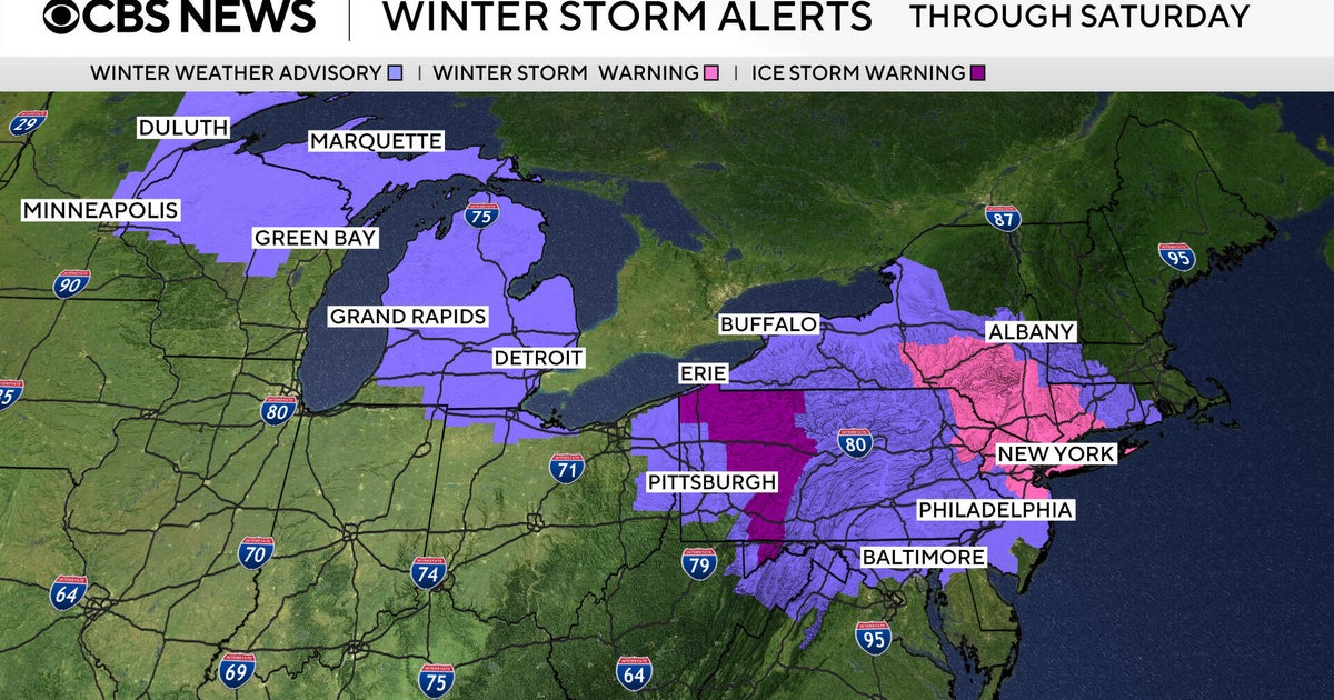
Widespread Travel Chaos and Alerts
The storm's arrival has immediately impacted travel, with more than 1,400 flights canceled across the U.S. on Friday, and thousands more experiencing delays, according to FlightAware. Roads are expected to become slick and treacherous from the Upper Midwest through the Mid-Atlantic due to freezing rain and sleet.
- Winter Storm Warnings are in effect from Friday afternoon through midday Saturday for the New York City Tri-State area, encompassing northern New Jersey, most of Long Island, the Hudson Valley, and western Connecticut.
- An Ice Storm Warning has been issued through Saturday morning for central Pennsylvania counties, including Somerset, Westmoreland (ridges), Indiana, Armstrong, Clarion, Jefferson, Forest, and Venango.
- Residents in affected areas are strongly advised to complete necessary travel by Friday afternoon and stay off roads through Friday evening and overnight into Saturday.
Regional Impacts: Ice, Sleet, and Significant Snowfall
The storm presents a diverse set of challenges across different regions:
New York City Prepares for Major Snow Event
The New York City metropolitan area is bracing for what is expected to be its biggest snowfall in nearly four years. Forecasts predict 4 to 8 inches of snow, with some northern communities potentially seeing up to 10 inches. Locally higher amounts are possible in the Catskills and Pocono mountains.
CBS News New York meteorologist Tony Sadiku warned of “moderate to heavy snow that could accumulate pretty quickly — inch or two an hour snowfall rates will mean treacherous conditions on the road, poor visibility, slick conditions right through the overnight hours.” The last time NYC saw more than 4 inches was January 28-29, 2022, when Central Park received 8.5 inches.
For the Jersey Shore and central New Jersey, snowfall totals are expected to be slightly lower, around 3 to 5 inches, due to a mix of freezing rain and sleet.
Ice: The Primary Threat for Central Pennsylvania and Beyond
Ice accumulation is the most significant concern for an area stretching from central Michigan through southwestern New York and into central Pennsylvania. Central Pennsylvania counties under an ice storm warning could see a quarter-inch or more of ice.
- CBS News Detroit reports that freezing rain and sleet will make roads extremely treacherous across Lapeer, Lenawee, Livingston, Macomb, Monroe, Oakland, Washtenaw, and Wayne counties.
- CBS News Pittsburgh indicates that while most of the Pittsburgh metro area will see a brief window of freezing rain before it turns to rain, portions of central Pennsylvania will face considerable ice accumulation.
Mid-Atlantic Braces for Wintry Mix
The storm will approach the Philadelphia area Friday afternoon, with CBS News Philadelphia meteorologists advising residents to “Be where you need to be by 3 p.m. on Friday if you can,” and to stay off the roads. Further south, CBS News Baltimore warns of a slick wintry mix of freezing rain and sleet developing Friday afternoon for parts of central and northern Maryland.
Storm at a Glance: Regional Forecasts
| Region | Primary Concern | Forecast/Impacts |
|---|---|---|
| New York City Area | Snow | 4-8 inches (up to 10 in northern communities/mountains), treacherous conditions, poor visibility, biggest snowfall in nearly 4 years. |
| Central Pennsylvania | Ice | Ice accumulation of 0.25 inches or more, ice storm warning. |
| Upper Midwest / Michigan | Ice, Sleet | Extremely treacherous roads, freezing rain and sleet. |
| Jersey Shore / Central NJ | Snow, Mix | 3-5 inches snow, mixed with freezing rain and sleet. |
| Philadelphia Area | Mixed bag | Approaching Friday afternoon; residents advised to be off roads by 3 p.m. Friday and stay off through Saturday. |
| Baltimore Area | Wintry Mix | Slick freezing rain and sleet for parts of central and northern Maryland Friday afternoon. |
| Great Lakes & Northeast | General | Winter storm packing ice and snow, slick roads, winter weather advisories, winter storm warnings, 1,400+ flights canceled, thousands delayed. |
